How GIS can be used as a response system during natural calamity
How GIS can be used as a response system during natural calamity
Disasters are said to be spatial in nature and in recent years we can see an increase in intensity and occurrence of disasters. Statistically, between 2000 and 2019, over 4 billion people worldwide were affected by disasters and over 1.2 million people lost their lives. These natural and man-made calamities have the potential to turn into cascading disasters which can lead to massive destruction, loss of life and property. Uttarakhand, a state in the Northern part of India, in the month of February, 2021, experienced flash floods which caused an unprecedented damage to life and property. It can be said that it will take time to reach a state of normalcy.
Source: Alja-Zeera
Though the occurrence of disasters cannot be prevented but it is possible to be prepared to face the disasters before they occur and have plans in place to execute once disasters have occurred in order to minimize the loss of property and lives. The advances in technology and possibility of integrating GIS and remote sensing to all phases of disaster management has made us capable of mitigating such calamities.
WHAT IS GIS?
GIS or Geographic Information Systems is a tool that captures geographic data for the purpose of manipulation, viewing and analysis. In technical terms, it is a computer system that captures, stores, checks, and displays data related to locations on the Earth’s surface.
Used to analyze spatial data or geographic information for any given and possible purpose, in today’s time – GIS is the go-to technology for location-based decisions. One of the sectors that majorly depends on GIS for reducing risks is disaster management. Playing a fundamental role in understanding the current and future issues involving geographic space, GIS positively builds as a response system for disaster management. From assisting in locating the potential hazard exposure to preparing for quick strategies – GIS has the potential to be used as a response system during disasters.
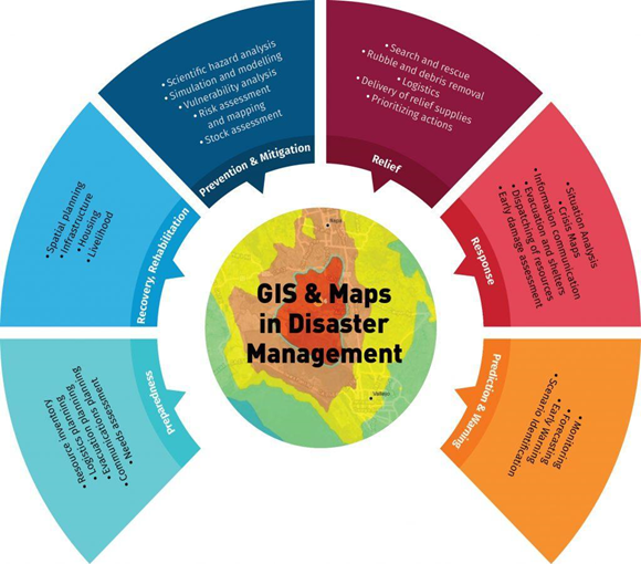
GIS AS RESPONSE SYSTEM FOR DISASTER MANAGEMENT
The Disaster Management sector is responsible for creating awareness of any possible natural calamities to happen in the near-future. With the help of the GIS tools, these teams make a proper plan of mitigation, response, rescue and evacuation. Their primary responsibilities involve –
Identifying and mapping the disaster prone areas
Planning safety measures beforehand
Planning rescue and evacuation
Rehabilitation and post disaster management
Source: RMSI
WAYS GIS HELPS IN DISASTER MANAGEMENT
GIS as a tool has the power to collect data from various sources to be used for a common purpose on a common platform. These readily accessible data of critical information help to plan efficient disaster management in cases of emergencies. Some ways GIS has been helping in mitigating natural calamities are –
GIS helps in creating the map of disaster affected areas
Can allow the mapping of evacuation routes by use of imagery captured.
If a weather forecast is available then the government officials can take appropriate decisions based on the available maps and locations.
Create disaster maps to show the risk zones as well as disaster impact zones.
Helps in mapping evacuation routes
Shelter planning
Identifies debris removal strategies
Used for storing digitized maps, their visualization and analysis.
Helps in re-establishing communication
Gives an estimate of economic impacts and social impacts
Useful in connecting dislocated families and sending helps to them
Identifying the medicals and hospitals for treatment nearby
Helps to find shelter and camps that one can easily reach in the nearby places
Identifying safe disaster prone places where shelters and camps can be organized with the help of maps.
Help secure relief funding
HOW GISKERNEL CAN HELP IN DISASTER MANAGEMENT?GISKernel provides specialized services and consulting to harness the power of GIS to build an effective response system for disaster management business. We can help you with mapping of the geographic terrain, collecting data about past and current disasters, secure relief funds and much more.
GISKernel makes use of a variety of different spatial, temporal, and spectral resolutions to provide you with better data and helps you with –
Hazard mapping for flood plains and fault lines, fire hazards, earthquakes and more
Identifying, following and analysing the potential destruction of disaster
Using remote sensing to gauge initial destruction, to infrastructure in the case of an earthquake or terrorist attack
Tracking the location and supply levels of support and rescue teams following an emergency event
Creating computer-generated maps of infrastructure including pipes, sewers, power lines, neighbourhoods’ and other aspects of an area so the map can be referenced in preparedness, emergency and recovery efforts
Source: geospatial-world
Information about emergency headquarters (i.e police, fire, ambulance) for quickest response during the time of emergency
Identifying potentially vulnerable residents in case of a disaster, in terms of age, income and other insights
Tracking terrorist attacks, sabotage and other threats to national security using geospatial information technology
Using sensors on airplanes or satellites (remote sensing) to record events such as storms and to integrate that information into a geographic information system
Finding current evacuation routes that have been updated as a result of the disaster at hand
GISKernel works in a number of different industries such as Agriculture, Automobile, Disaster Management, Oil and Gas, Telecom, Public Safety, Municipality etc. We are looking forward to serving you in the best geo-spatial way possible.
Manage Consent
To provide the best experiences, we use technologies like cookies to store and/or access device information. Consenting to these technologies will allow us to process data such as browsing behavior or unique IDs on this site. Not consenting or withdrawing consent, may adversely affect certain features and functions.
Functional
Always active
The technical storage or access is strictly necessary for the legitimate purpose of enabling the use of a specific service explicitly requested by the subscriber or user, or for the sole purpose of carrying out the transmission of a communication over an electronic communications network.
Preferences
The technical storage or access is necessary for the legitimate purpose of storing preferences that are not requested by the subscriber or user.
Statistics
The technical storage or access that is used exclusively for statistical purposes.The technical storage or access that is used exclusively for anonymous statistical purposes. Without a subpoena, voluntary compliance on the part of your Internet Service Provider, or additional records from a third party, information stored or retrieved for this purpose alone cannot usually be used to identify you.
Marketing
The technical storage or access is required to create user profiles to send advertising, or to track the user on a website or across several websites for similar marketing purposes.