Simplify Field Data Collection with ArcGIS Field Maps Designer
Introducing ArcGIS Field Maps Designer.
Tired of inefficient data collection, manual errors, and delayed insights from the field? While many apps address parts of the challenge, ArcGIS Field Maps Designer stands out as the ultimate all-in-one solution, seamlessly blending powerful mapping, intelligent forms, and real-time data sync to empower your teams like never before. Whether you’re conducting vital inspections, precisely recording assets, or capturing critical field observations, Field Maps Designer offers unparalleled flexibility and visual clarity, transforming every fieldwork scenario into an opportunity for accurate, actionable data.
Unlock Peak Efficiency with Field Maps Designer: Your Command Center for Field Data
ArcGIS Field Maps Designer is not just a tool; it’s your strategic web-based command center for flawless field data management.
It empowers you to:
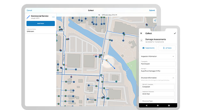
- Design Intelligent Forms: Craft intuitive, smart data collection forms tailored to your exact needs.
- Optimize for Any Environment: Effortlessly set up offline map areas, ensuring uninterrupted productivity.
- Enable Live Intelligence: Facilitate real-time synchronization with your feature layers, instantly updating your GIS.
- Equip Your Mobile Workforce: Prepare comprehensive, mobile-ready maps that guide your field teams with precision.
Key Benefits
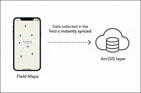
Real-time Data Updates for Instant Insights:
Field Maps acts as a smart client, communicating directly with ArcGIS web services to provide live data updates. Our robust backend handles authentication, rigorous data validation, and seamless database writes, ensuring that updated, critical information is immediately accessible to every stakeholder viewing that layer. Say goodbye to data lag and hello to immediate, actionable intelligence! viewing that layer.Intelligent Smart Forms for Guaranteed Accuracy:
Our smart forms leverage powerful logic, including conditional visibility, automated calculations, and built-in constraints, using Arcade expressions or predefined rules9. This dynamic guidance minimizes errors, standardizes data capture, and ensures your teams collect complete, accurate information every single time.Uninterrupted Productivity with Robust Offline Support:
Field Maps Designer’s unparalleled offline capabilities allow your teams to download pre-packaged map areas—complete with basemaps and editable feature layers—directly onto their devices. All edits, new features, and attachments are securely stored locally. When connectivity is restored, only the changes are seamlessly synced back to the central database, where ArcGIS intelligently merges updates, guaranteeing data integrity even in the most remote locations.

Field Maps Designer in Action: Real-World Impact Across Industries.
Discover how leading organizations are leveraging Field Maps Designer to overcome complex challenges and achieve remarkable results:
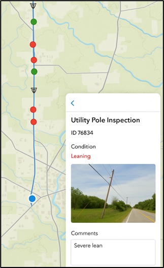
1. Utilities – Accelerate Post-Storm Asset Condition Assessment:
After major storm events, utility companies deploy field crews armed with Field Maps Designer.
Staff swiftly:
- Access critical, pre-loaded GIS layers (e.g., transmission lines, substations, flood zones).
- Utilize real-time GPS tracking for precise navigation to asset locations.
- Capture high-resolution images of vital damage like leaning poles or insulator failures.
- Update asset condition attributes (e.g., crack size, pole tilt angle) instantly.
- Sync updates directly to the enterprise GIS, triggering automated dashboards for immediate management oversight and prioritized repair scheduling.
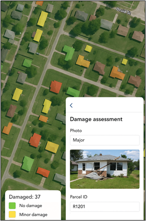
2. Disaster Response – Rapid Damage Assessment & Coordinated Recovery:
In the immediate aftermath of a hurricane, emergency management teams gain unprecedented agility:
- Field Maps Designer provides standardized, domain-controlled forms for rapid, accurate building damage assessments (e.g., Minor, Major, Destroyed).
- Teams efficiently collect geotagged images and capture parcel-level locations.
- Offline maps with pre-downloaded aerial imagery ensure continuous operation, even without connectivity.
- Data syncs automatically to central operations, feeding real-time damage heat maps for vital state and FEMA reporting, accelerating aid delivery.
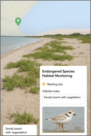
3. Environmental – Precision Habitat Monitoring & Compliance:
Conservation biologists tracking endangered species gain unparalleled control:
- Field Maps utilizes geofencing alerts to prevent entry into sensitive buffer zones, ensuring compliance.
- Teams collect precise habitat variables (nest height, vegetation type, water proximity) with ease.
- Time-stamped photos and weather conditions are directly recorded in the app.
- Conditional visibility logic ensures relevant fields appear only when needed (e.g., protected buffer violation fields if species = “Bald Eagle”).
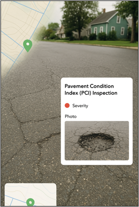
4. Public Works – Streamline Pavement Condition Inspections & Maintenance:
Public Works departments optimize routine Pavement Condition Index (PCI) surveys:
- Field crews efficiently capture pothole size/depth, crack density, and surface rutting.
- Real-time imagery is uploaded for each segment.
- Condition scores are automatically calculated using built-in expressions within Field Maps Designer.
- Results seamlessly feed into GIS-driven work order management systems, enabling prioritized, efficient repair scheduling and optimized resource allocation.
Ready to Transform Your Field Data Collection?
Field Maps Designer brings together unparalleled map-centric data collection, intelligently configurable smart forms, and seamless, real-time integration with your enterprise GIS, effectively eliminating post-processing and manual data entry. By harnessing the full power of the ArcGIS platform, we ensure that high-quality, spatially accurate data flows directly from the field to your geodatabase, empowering superior analysis, faster decision-making, and dramatically more efficient operations across your entire organization.
Whether you’re a utility manager optimizing critical infrastructure, an environmental scientist ensuring compliance, a disaster response coordinator orchestrating rapid assessments, or a public works supervisor streamlining inspections, Field Maps Designer empowers your diverse stakeholders to collect, validate, and leverage geospatial data with unprecedented effectiveness. It’s time to enhance the integrity, consistency, and accessibility of your GIS data, ensuring everyone, from field technicians to executive decision-makers, operates from the same trusted source of information.
Don’t let outdated data collection methods hold you back. Contact us today to schedule a personalized demo and discover how ArcGIS Field Maps Designer can revolutionize your fieldwork and accelerate your path to data-driven success!
Authored by Rushikesh Aglave,
GIS Developer at GISKernel,
Specializing in geospatial application development and spatial data solutions.